


Insights / Drones & UAV
How Are Drones Used in Agriculture? Spraying, Scouting and Farm Data
The farm jobs drones do today, how a connected drone moves data between field and farm system, and the design choices that decide whether it works.

The short answer
Farms use drones for four main jobs: scouting and crop monitoring with RGB or multispectral cameras, targeted spraying of crop protection and foliar nutrients, livestock checks across large pastures, and, in narrower cases, seeding. What makes a drone useful beyond a single flight is connectivity: mission plans, telemetry, spray records and imagery move between the drone, a cloud platform and the farm management system, so each flight improves the next decision instead of ending as a file on an SD card.
Key takeaways
- A farm drone is an IoT device: it senses, acts, reports and can be updated remotely.
- Choose the data link per job: Wi-Fi offload at the base, cellular for live telemetry, satellite where nothing else reaches.
- Value comes from integration: spray records and crop maps have to land in the farm system, not stay on the drone.
- Existing airframes can often be connected with a data-link module instead of a full redesign.
Why connected drones matter on a farm
Many agricultural drones can already fly a field and spray it on their own. The common gap is what happens after landing. If mission data, spray logs and imagery stay on the aircraft, an agronomist cannot see which zones were treated, a contractor cannot prove what was applied, and the next mission is planned from memory.
Connecting the drone to the farm's data systems turns it from a stand-alone tool into one part of a precision-agriculture loop: observe, decide, act, record. That matters to drone OEMs, spraying contractors and agtech platforms alike.
How an agricultural drone works as an IoT device
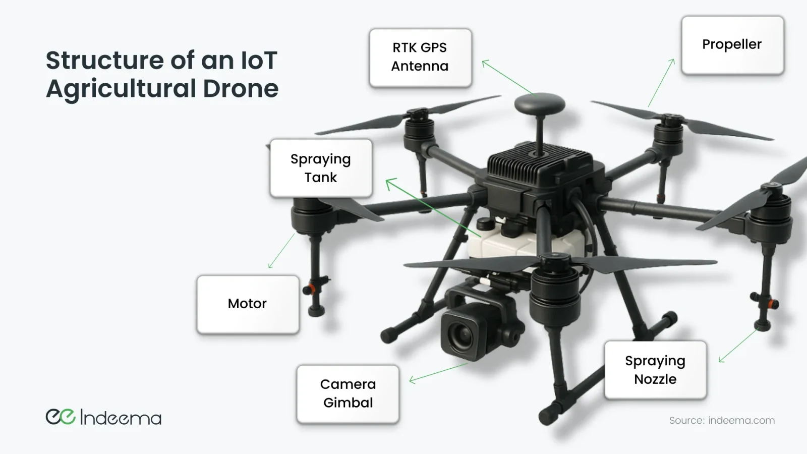
An autonomous farm drone carries a flight controller, satellite positioning (often with RTK correction for centimetre-level accuracy), cameras and other sensors, and, on spraying models, a tank, pump and nozzles. In IoT terms it collects data about its environment and its own equipment, communicates with other systems, and can be controlled or updated remotely.
- Variable-rate application
- Changing how much product a drone or sprayer applies, zone by zone, based on a prescription map or live sensor input, instead of applying one rate across the whole field.
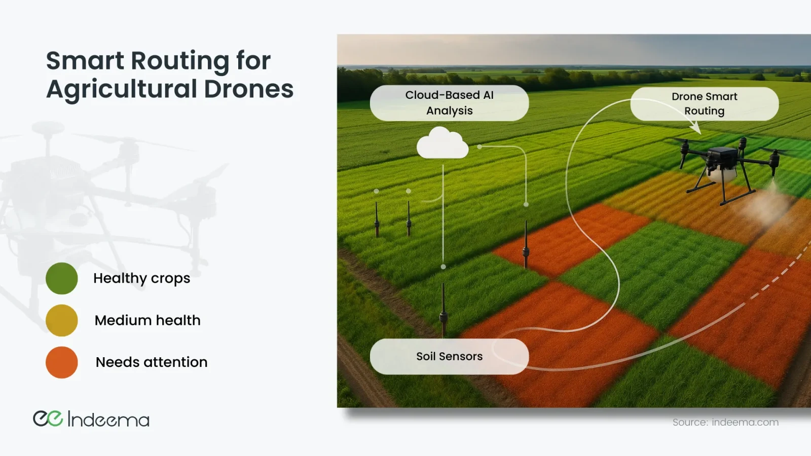
Because the drone can take inputs mid-flight, it can do more than follow a fixed route. It can adjust its path and spray rate from crop-health maps, soil-sensor readings or alerts from an analytics system.
What farmers use drones for
| Job | Typical payload | Data it produces | Where it fits best |
|---|---|---|---|
| Scouting and crop monitoring | RGB or multispectral camera | Crop-health (NDVI) maps, pest and storm-damage imagery | Spotting problems early across large fields |
| Targeted spraying | Tank, pump, nozzles, RTK positioning | Spray logs: what was applied, where and when | Paddies, orchards, vineyards, wet or steep ground |
| Livestock checks | RGB or thermal camera | Herd location and counts, imagery of animals | Large pastures that take hours to ride or drive |
| Seeding and biological control | Seed or beneficial-insect dispenser | Drop locations | Specialised cases such as reforestation or pilot projects |
Drones reach ground that heavy machinery would damage or cannot enter: waterlogged fields, steep slopes, narrow corners. Flying low with RTK guidance keeps altitude and spray width consistent, which limits drift. Each flight also produces data, which is where connectivity comes in.
Four ways farm drones are operated
- Pre-programmed missions: the drone follows a planned route, for example a grid survey every morning, with data uploaded automatically after landing.
- Triggered missions: an alert such as frost risk or a pest detection dispatches the drone to one zone to inspect or treat it.
- Variable-rate spraying: camera or sensor analysis, on board or in the cloud, changes how much is sprayed row by row.
- Coordinated fleets: one operator supervises several drones that split a large field and stagger landings for battery swaps and refills. Whether one person may fly several aircraft depends on local aviation rules.
Smart routing ties these together. Soil sensors and crop-health maps tell the cloud which zones need attention, and the drone is routed there first instead of covering the field evenly.
How drone data reaches the cloud and the farm system
A connected farm drone sends telemetry (position, speed, battery, tank level), spray records and imagery to an IoT platform, and receives mission updates in return. The link depends on where the drone flies and how much data must move.
| Link | Bandwidth | Range | Best use |
|---|---|---|---|
| Wi-Fi | High | Short, near a base station or vehicle | Offloading logs and imagery after a mission; configuration |
| 4G/LTE or LTE-M | Medium to high | Wherever there is coverage | Live telemetry and mission updates during flight |
| LoRa | Very low | Long | Basic status and position where bandwidth is not needed |
| Satellite | Low to medium, higher cost | Remote fields without cellular coverage | Telemetry and alerts where nothing else reaches |
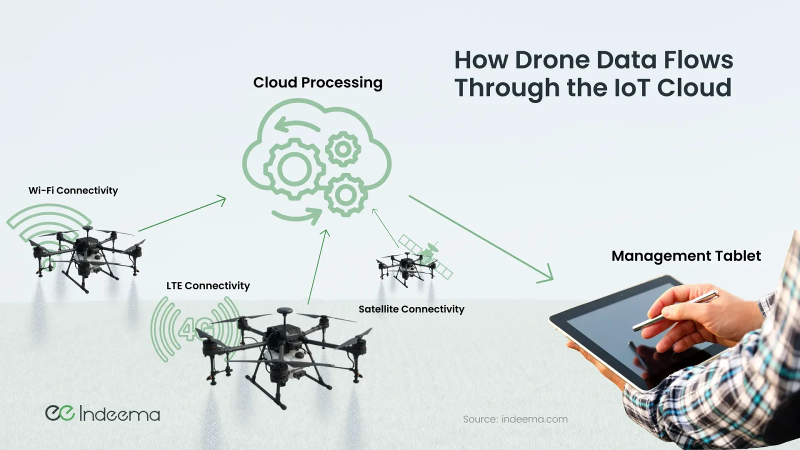
Once in the cloud, drone data has to join the rest of the farm's data: soil sensors, weather, satellite crop maps and the farm management system. That integration is what lets an agronomist see that a zone flagged on Monday was treated on Tuesday, and at what rate.
Where this shows up in our work: connecting a spraying drone
An agritech company building drones for crop protection asked us to make its spraying drones cloud-connected. The aircraft could already fly spraying missions, but after each flight there was no simple way to transfer mission data, sync logs or connect the drone to the wider farm data environment.
Our team built a Wi-Fi data-link module that sits between the drone's onboard electronics and the server. A bridge controller receives data from the drone's client controller over QSPI, writes logs to a console over UART, exposes a Wi-Fi access point for configuration, and joins a network as a Wi-Fi station to transfer data to the server.
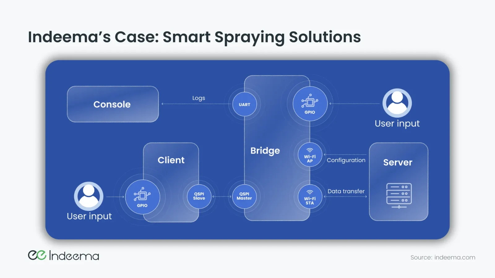
Mission and spraying records could then be stored, reviewed and combined with other farm tools, without rebuilding the existing airframe.
Engineering trade-offs
Offload data after landing vs stream it during flight
- You gain
- Offload over Wi-Fi is cheap, simple and moves large files; streaming gives live visibility and lets the plan change mid-mission.
- You pay
- Offload means no live view; streaming needs cellular or satellite coverage and a data plan, and still cannot carry raw video economically.
- Choose it when
- Offload for survey imagery and spray logs; stream compact telemetry and alerts when operators must react during the flight.
On-board analysis vs cloud analysis
- You gain
- On-board detection acts in the same pass and needs little bandwidth; cloud analysis can use larger models and combine many data sources.
- You pay
- On-board compute adds weight, power draw and update complexity; cloud analysis adds latency and depends on the link.
- Choose it when
- On board for spot spraying and obstacle handling; in the cloud for field-wide maps, trends and prescription planning.
Retrofit a data-link module vs redesign the electronics
- You gain
- A retrofit connects an existing, already-proven airframe quickly.
- You pay
- It inherits the existing interfaces and limits of the onboard electronics.
- Choose it when
- Retrofit when the airframe works and the gap is data; redesign when power, payload or certification needs have changed.
Before you connect a farm drone
Questions to settle before choosing hardware or a platform:
- List the data each mission must produce: spray records, coverage maps, imagery, telemetry.
- Decide what must be live during flight and what can wait until landing.
- Map the coverage on the fields you serve and choose the link per job, not per product.
- Define where the data ends up: which farm management or agronomy system, in what format.
- Plan secure device identity and signed firmware updates for every aircraft in the fleet.
- Check the aviation and crop-protection rules in each country you operate in; they differ and change.
Where we've built this
Case studyA Wi-Fi data-link firmware prototype for an agricultural drone makerA spraying drone that already flew its missions, connected to the cloud with a Wi-Fi data-link module so mission and spray data no longer stayed on the aircraft.Questions engineers ask
How are drones used in farming?
Mainly for crop scouting with RGB or multispectral cameras, targeted spraying of crop protection and nutrients, checking livestock on large pastures and, in specialised cases, seeding. Connected drones also feed their records into the farm management system.
How do drones improve farm productivity?
They cover ground quickly, reach fields that machinery cannot enter, and apply product only where it is needed. The data from each flight helps the next decision, such as which zones to treat first.
How are drones used for agricultural purposes beyond spraying?
Survey drones build crop-health maps and record storm or pest damage, thermal cameras help find and count animals, and some projects use drones to drop seeds or beneficial insects.
Was this useful?
Where this shows up in our work
SolutionAutonomous & Intelligent Physical Systems EngineeringConnecting drones to the cloud, running detection at the edge and tying field data into farm systems is the autonomous and physical systems work we do across firmware, electronics and cloud.For what changes when the drone itself is the product, from flight stack to fleet software, see UAV and drone systems engineering.
Apply this to your product